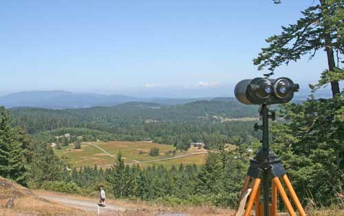
A thin haze lingered out on the horizon that obscured all but the snow-capped peaks of two of the northern Cascades tallest mountains.
Even so, the promise of Mount Grant was clearly visible to many of those assembled on its summit for the May 31 kick-off of a fundraising campaign aimed directly at making its auto-accessible peak and the 141 acres of woodlands that surround it the newest publicly owned nature preserve in San Juan County.
“There’s just too many superlatives,” Cal Ryan said of the view from atop the 710-foot-tall peak.
A San Juan Island resident of 34 years, Ryan, accompanied by wife Mary Karen and son Bobby, and friends, made a first-ever foray to the summit of what long has been a privately owned mountaintop and forested woodlands to see for himself what all the talk was about.
“I’ve never seen the island from this view,” said Ryan, while spying the family’s San Juan Valley farm out in the distance, far below.
Like the Ryans, more and more islanders have become familiar with the unique setting that is Mount Grant, formerly known as Lawson’s Ridge, since the San Juan Preservation Trust and the Land Bank joined forces on a plan to purchase and preserve the property, and then plunked down a $1 million down payment in mid-March on a pending $3 million purchase.
Flanked by Trout Lake to the south and Lawson’s Pond to the north, Mount Grant sits in between Cady Mountain and Mount Dallas. It’s only a smidge smaller than both and its craggily summit offers expansive views in all directions for as far as the eye can see.
Its peak has been a beacon for clandestine hikers over the years and a series of hiking tails through the woodlands below is part of the plan.
But the truly unique feature offered by Mount Grant is the gravel road that leads to the summit. A vestige of a once-planned-for and partially developed subdivision of 12 lots, it will be a gateway to the peak of a nature preserve, much like the road leading to the top of Orcas Island’s Mount Constitution, for those to whom a hefty hike could prove too much of a challenge.
It’s because of that road that Mount Grant offers something that can’t be found even at the renowned Turtleback Mountain Preserve, Preservation Trust Director Tim Seifert said.
“There are people who’ve never been to the top of Turtleback because they can’t get there,” he said. “People are a big part of these islands and it’s important to have access to some these unique places.”
In addition to the road, hiking trails, mostly undisturbed woodlands and the summit and the 360-degree views, the condition and sheer size of the would-be preserve make the property a one-of-a-kind opportunity, Land Bank Director Lincoln Bormann said.
“It’s one of the last places where we can make a big impact,” he said.
Still, whether such an impact becomes reality rests with the fundraising campaign. The two land conservation agencies face an early September deadline on another installment on a seller-financed loan, followed by another in early 2016.
The Land Bank has committed $1.5 million toward purchase of the property and the Trust is seeking to raise $2.7 million to cover the balance of the sale price and to establish a stewardship fund for restoration and maintenance of the property. To help spark the fundraising campaign, a local family has offered to match up to $500,000 in pledges and donations collected before Sept. 1.
While its promise may be crystal clear, whether Mount Grant joins the fold of the island’s nature preserves remains to be seen.
The Ryan family is allied with those hoping that it will.
“This view is stunning,” Mary Karen Ryan said. “We’re definitely coming back.”
— Editor’s note: The Mount Grant hiking trails are open seven days a week, until dusk. Presently, automobile access is prohibited; however, plans are in the works whereby the road may be open on a certain day of the week, and guided trips to the summit are available for groups by appointment. For info, contact the Land Bank, 360-378-4402.


